Les actualités de la BRVM en Flux RSS
Nous agrégeons les sources d’informations financières spécifiques Régionales et Internationales. Info Générale, Economique, Marchés Forex-Comodities- Actions-Obligataires-Taux, Vieille règlementaire etc.
Enjoy a simplified experience
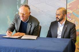
Find all the economic and financial information on our Orishas Direct application to download on Play StoreEsri President Jack Dangermond and Space42 CEO Hasan Al Hosani sign a Memorandum of Understanding (MOU) at the Esri User Conference. The collaboration will provide a high-resolution cartographic background to support economic growth and innovation across the continent
.Esri, a global leader in geospatial intelligence, has signed a Memorandum of Understanding (MoU) with Space42 and Microsoft to support the “Map Africa” initiative. The aim of this five-year project is to produce the most comprehensive map of Africa to date. This initiative will provide high-resolution and scalable geospatial data across all 54 African countries, benefiting over 1.4 billion people
.Many official African maps are fragmented, outdated, or difficult to access, requiring governments and businesses to make important decisions with inaccurate or incomplete data. This has led to infrastructure development difficulties, as well as investment and institutional gaps. This joint initiative between Esri, Space42, and Microsoft was formalized in early July at the 2025 Esri User Conference in San Diego, California. This collaboration aims to strengthen the institutional capacities of African countries by providing locally-managed geospatial data and by enabling governments, businesses, and communities to make more informed decisions
.“We are proud to support the Map Africa initiative in partnership with Space42,” said Jack Dangermond, President of Esri. “Transforming satellite images into detailed and accurate base maps on a continental scale requires advanced geospatial technology and professional workflows. These same capabilities have supported similar national and regional mapping efforts around the world. With Map Africa, we are contributing to the creation of a fundamental resource that will drive infrastructure planning, economic growth and sustainable development across the continent.
”space42, an Emirati company specializing in AI and space technology, will lead fundraising and project management, in addition to providing satellite data. Esri will orchestrate basemap workflows through its GeoAI and remote sensing capabilities, while supporting regional platforms to train local teams and develop long-term capabilities. Microsoft will provide the secure cloud infrastructure and AI framework through Azure to support data processing, sharing, and integration at scale.
“Partnership is at the core of the UAE's DNA and is at the core of how Space42 operates,” said Hasan Al Hosani, CEO of Smart Solutions at Space42. “This collaboration with Microsoft and Esri is more than technical; it's strategic. It advances Space42's business priorities, reinforces our role as a trusted partner with governments, and provides significant benefits to African communities. Accurate, high-quality mapping, and the intelligence solutions that flow from it, are critical to growth, resilience, and inclusive innovation. With reliable data, communities and economies thrive.
”Map Africa data will be licensed to national governments, allowing national mapping agencies to own and update it in the long term. Ultimately, the initiative will also support a new commercial ecosystem of African startups
.
Vous devez être membre pour ajouter un commentaire.
Vous êtes déjà membre ?
Connectez-vous
Pas encore membre ?
Devenez membre gratuitement

01/08/2025 - Secteurs

01/08/2025 - Secteurs
01/08/2025 - Secteurs
01/08/2025 - Secteurs

31/07/2025 - Secteurs
31/07/2025 - Secteurs
31/07/2025 - Secteurs
31/07/2025 - Secteurs
01/08/2025 - Secteurs
01/08/2025 - Secteurs
01/08/2025 - Secteurs